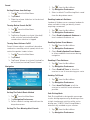
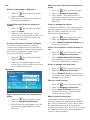
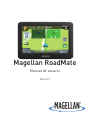
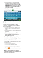
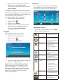
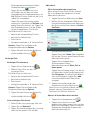
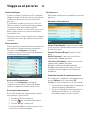
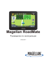
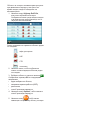
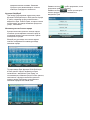
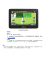
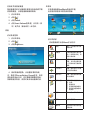
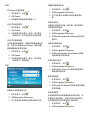
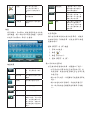
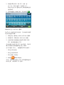
Magellan roadmate 5620-LM Manual do usuário
- Categoria
- Navegadores
- Tipo
- Manual do usuário
Este manual também é adequado para

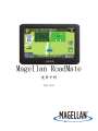
Magellan RoadMate
User Manual
2016-2017

IMPORTANT SAFETY WARNINGS
Keep the Magellan RoadMate receiver safe
from extreme temperature conditions. For
example, do not leave it exposed to direct
sunlight for an extended period of time.
Take care when mounting the Magellan
RoadMate receiver in your vehicle, whether
using the windshield mount or other mounts,
that it does not obstruct the driver’s view of
the road, interfere with the operation of the
vehicle’s safety devices such as air bags, or
present a hazard to occupants of the vehicle
should the receiver be dislodged while driving.
It is your responsibility to assess the risks
associated with damage to your vehicle or
vehicle occupants as the result of your choices
in mounting the Magellan RoadMate receiver.
Temperature
The maximum operating temperature is 140°F
(60°C).
Battery
The battery in the Magellan RoadMate receiver
is rechargeable and should not be removed. In
the event that it should need to be replaced,
please contact Magellan Technical Support.
Charging the Magellan RoadMate
An optional AC adapter is available as an
accessory for your Magellan RoadMate. Use
of another type of AC adapter can result in
malfunction and/or possible fire hazard due to
battery overheating.
Only use the car charger approved for/supplied
with your Magellan RoadMate receiver. Use of
another type of car charger will result in fire or
electric shock.
For safety reasons, the battery in your
Magellan RoadMate receiver will stop charging
when the ambient temperature is less than
32°F (0°C) or more than 113°F (45°C).
It will take approximately 4 hours of charging
the Magellan RoadMate receiver through
the vehicle power adapter or optional AC
adapter to obtain a full battery charge. It is
The Magellan RoadMate receiver is a vehicle-
navigation aid designed to assist you in arriving
at your selected destinations. When using
the Magellan RoadMate receiver, these safety
rules must be followed to prevent accidents
that can result in injury or death to yourself or
others:
Please check the applicable regulations in your
state regarding windshield mounting. Certain
states prohibit the mounting of any items on
your windshield. Go to www.magellanGPS.com
for alternative mounting solutions.
When driving, the need to view the display is
minimal. Voice prompts will guide you to your
destination. The driver should enter data or
program the Magellan RoadMate receiver only
when the vehicle is stationary. Only a vehicle
passenger should enter data or program the
Magellan RoadMate receiver while the vehicle
is moving. Do not become distracted by the
receiver while driving, and always be fully
aware of all driving conditions.
It is your responsibility to comply with all
traffic laws and to use the Magellan RoadMate
and mounting options in such a manner that
the user is in compliance with applicable laws.
Roads, points of interest (POIs), business
and service locations may change over
time. As a result the database may contain
inaccuracy. Also, the database does not
include, analyze, process, consider, or
reflect any of the following: legal restrictions
(such as vehicle type, weight, height, width,
load and speed restrictions); road slope or
gradient; bridge height, width, weight or other
limits; population density; neighborhood
quality or safety; availability or proximity of
police, emergency rescue, medical or other
assistance; construction work zones or
hazards; road or lane closures; road, traffic or
traffic facilities’ safety or condition; weather
conditions; pavement characteristics or
conditions; special events; traffic congestion. It
is your responsibility to disregard any unsafe,
hazardous or illegal route suggestions.

recommended that you charge the battery
initially for at least 2 hours.
Use only the charger approved for your
Magellan RoadMate receiver.
Estimated usage of the Magellan RoadMate on
battery power is approximately 2 hours.
Federal Communication Commission
Interference Statement
This equipment has been tested and found
to comply with the limits for class B digital
devices, in accordance with part 15 of the
FCC Rules. These limits are designed to
provide reasonable protection against harmful
interference in a residential installation.
This equipment generates, uses and can
radiate radio frequency energy and, if not
installed and used in accordance with the
instructions, may cause harmful interference
to radio communications. However, there is
no guarantee that interference will not occur
in a particular installation. If this equipment
does cause harmful interference to radio or
television reception, which can be determined
by turning the equipment off and on, the user
is encouraged to try to correct the interference
by one of the following measures:
Reorient or relocate the receiving antenna.
Increase the separation between the
equipment and receiver.
Connect the equipment into an outlet on a
circuit different from that to which the receiver
is connected.
Consult the dealer or an experienced radio/TV
technician for help.
This device complies with Part 15 of the FCC
Rules. Operation is subject to the following
two conditions: (1) This device may not cause
harmful interference, and (2) this device must
accept any interference received, including
interference that may cause undesired
operation.
FCC Caution:
Any changes or modifications not
expressly approved by the party responsible for
compliance could void the user’s authority to
operate this equipment.
IMPORTANT NOTE:
FCC Radiation Exposure Statement:
This equipment complies with FCC radiation
exposure limits set forth for an uncontrolled
environment. End users must follow the
specific operating instructions for satisfying
RF exposure compliance.
This transmitter must not be co-located
or operating in conjunction with any other
antenna or transmitter.
In order to maintain compliance with FCC
regulations, shielded cables must be used with
this equipment. Operation with non-approved
equipment or unshielded cables is likely to
result in interference to radio and TV reception.
The user is cautioned that changes and
modifications made to the equipment without
the approval of manufacturer could void the
user’s authority to operate this equipment.
Tested To Comply
With FCC Standards
FOR HOME OR OFFICE USE
Magellan RoadMate
The Magellan RoadMate receiver must be
installed and operated at a distance no closer
then 8 inches (20 cm) from the user.
This Class B digital apparatus meets all
requirements of the Canadian Interference-
Causing Equipment Regulations.
IC statement
This device complies with Industry Canada
licence-exempt RSS standard(s). Operation is
subject to the following two conditions:
1. This device may not cause interference
and
2. This device must accept any interference,
including interference that may cause
undesired operation of the device.

IMPORTANT NOTE:
IC Radiation Exposure Statement:
This equipment complies with IC radiation exposure limits established for an uncontrolled
environment. End users must follow the specific operating instructions for satisfying RF exposure
compliance.
This transmitter must not be co-located or operated in conjunction with any other antenna or
transmitter.
One or more claims of the following patents may cover this product: U.S. patent No. 5,544,060, U.S.
patent No. 5,654,892, U.S. patent No. 5,832,408 and U.S. patent No. 5,987,375
The information provided in this document is subject to change without notice. Improvements
and enhancements to the product may occur without any formal notification. Check the Magellan
website (www.magellanGPS.com/support) for product updates and additional information.
Canada, avis d’Industry Canada (IC)
Le présent appareil est conforme aux CNR d’Industrie Canada applicables aux appareils radio
exempts de licence. L’exploitation est autorisée aux deux conditions suivantes : (1) l’appareil
ne doit pas produire de brouillage, et (2) l’utilisateur de l’appareil doit accepter tout brouillage
radioélectrique subi, même si le brouillage est susceptible d’en compromettre le fonctionnement.
© 2016-2017 MiTAC International Corporation. The Magellan logo, Magellan, RoadMate and Quickspell are
registered trademarks of MiTAC International Corporation. SmartDetour and OneTouch are trademarks of
MiTAC International Corporation and are used under license by MiTAC International Corporation. All rights
reserved.
All other products and brand names are trademarks of their respective holders.
No part of this user manual may be reproduced or transmitted in any form or by any means, electronic or
mechanical, including photocopying and recording, for any purpose other than the purchaser’s personal use,
without the prior written permission of MiTAC International Corporation.
The information provided in this document are correct at the time that it is created.
MiTAC International Corporation assumes no responsibility or liability for any errors or inaccuracies that may
appear in the contents of this User Manual.
112-0120-001
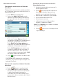
This user manual will give you the necessary
information on how to use the various features of the
Magellan RoadMate receiver.
Visit us at magellanGPS.com/support

Table of Contents
Magellan RoadMate GPS Receiver ....................................................................................................6
Getting Started ..................................................................................................................................8
Map Screen ..................................................................................................................................... 12
Selecting a Destination ................................................................................................................... 15
Points of Interest (POI) .................................................................................................................... 19
Traveling on a Route ........................................................................................................................ 21
OneTouch Menu ............................................................................................................................... 23
Traffic .............................................................................................................................................. 25
Settings ............................................................................................................................................ 26
Warranty .......................................................................................................................................... 32
Other Languages
Franais (French) ............................................................................................................................ 33
Español (Spanish) ............................................................................................................................ 65
Deutsch (German) ........................................................................................................................... 97
Italiano (Italian) ............................................................................................................................. 129
Português (Portuguese) ................................................................................................................ 161
русский (Russian) ..................................................................................................................... 193
Simplified Chinese ........................................................................................................................ 225
Traditional Chinese ....................................................................................................................... 257

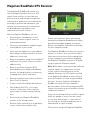
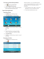
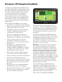
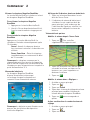
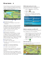
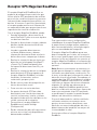
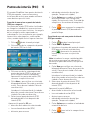
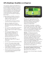
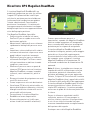
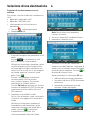
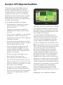
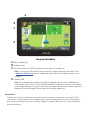
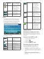
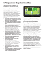
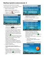
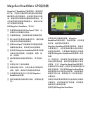
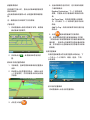
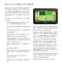
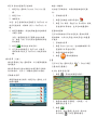
Magellan RoadMate GPS Receiver
The Magellan® RoadMate® receiver is a
vehicle navigation product that uses GPS
signals from satellites to calculate your
precise location and compute navigational
information to guide you to your destination.
Knowing its position and movement, your
receiver can then overlay this information
on detailed maps to provide a visual
representation of your location.
With the Magellan RoadMate, you can:
• Save searches and addresses to the
OneTouch™ menu for quick access to
favorite destinations.
• Store your home address and quickly get
routing details to your home.
• Enter and save addresses in your address
book and get routing information to those
addresses at any time.
• Route to an address using the QuickSpell™
and Smart City search for easy, errorless
address entry.
• Route to any Point of Interest (POI)
preloaded into your Magellan RoadMate
receiver, including hospitals, restaurants,
shopping malls, parks, and more.
• Receive navigation instructions with Voice
Alerts (Text-to-Speech).
• Create a route with multiple destinations.
• View Highway Exit POIs, a list of gas
stations, restaurants, hotels and auto
repair shops located at nearby highway
exits.
• Personalize your Magellan RoadMate
receiver in the Settings menu.
• Receive traffic information to avoid delays
in your travel (select models only).
Create and customize routes and settings,
knowing that Magellan RoadMate will always
provide cutting-edge mapping, low-power
battery consumption, and secure technology
for your navigation needs.
The Magellan RoadMate receiver has a built-in
battery so, in most cases, you will be able to
follow these instructions while reading them
on your computer screen without plugging
the Magellan RoadMate receiver to AC power
using an optional AC power adapter.
Note: While indoors, you may not get sufficient
satellite signals to compute your location,
so your location information may not be
updated. However, the GPS chipset installed
in the Magellan RoadMate receiver will pick
up satellite signals in some very demanding
locations. You may find that the Magellan
RoadMate receiver will even compute a
position indoors. Even with the improved GPS
chipset, the receiver may not be able to always
compute a fix indoors.
If you are not getting sufficient satellite signals
while in a garage or other structure, move
to a location where there is a clear view of
the sky, and you should immediately see an
improvement in signal strength.
Thank you for using the Magellan RoadMate.

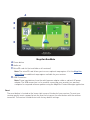
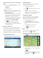
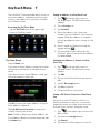
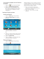
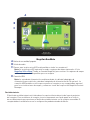
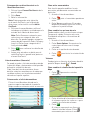
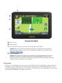
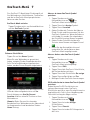
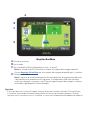
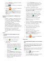
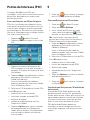
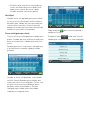
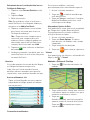
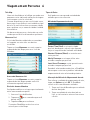
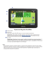
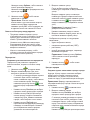
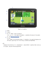
Magellan RoadMate
A Power button
B Audio out
C MicroSD card slot (not available on all receivers)
Note: The microSD card allows you to access optional map regions. Visit the Magellan
Online Shop for additional map regions available for your receiver.
D USB Connection
Note: Power input derives from the vehicle power adapter cable or optional AC power
adapter. The USB connection is also used for connecting your receiver to a personal
computer for map and software updates using the Magellan Content Manager application.
Reset
The reset button is located on the lower right corner of the back of your receiver. To reset your
receiver, gently insert a paperclip into the reset hole to press the reset button with the receiver
turned on. The receiver should restart with factory default settings.
A
B
D
C

Getting Started 2
Powering on the Magellan RoadMate receiver
The Power On/Off switch is located on the top
of the Magellan RoadMate receiver.
Turning the Magellan RoadMate receiver On
1. Press the power switch.
2. Read and tap after the initial splash
Warnings screen is displayed.
Turning the Magellan RoadMate receiver Off
Press the power switch. The receiver will
automatically power off in 15 seconds.
Cancel: Cancels the power off sequence
and returns to last viewed screen.
Power Down Now: Turns the receiver off
immediately, bypassing the 15 second
delay.
Note: The receiver will begin the power
off sequence anytime the power cable is
disconnected from the receiver or power is
turned off at the 12 V power receptacle.
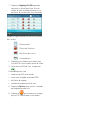
Battery Levels
The Magellan RoadMate receiver has an
internal battery that charges whenever the
receiver is connected to external power.
Note: The battery can only be serviced by
authorized Magellan repair facilities.
Viewing the Battery Level Indicator
1. Tap on the Menu button in the right
corner of the Map screen.
2. The battery level indicator is located in
the upper right corner of the Main Menu,
just below the satellite signal indicator.
Green bars indicate battery level.
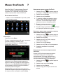
Speaker Volume
Changing the Volume from the Map Screen
1. Tap . Additional controls appear.
2. Tap the speaker button to mute the
volume, or tap the + or - buttons to raise
or lower the volume.
3. Tap .
Changing the Volume from Settings
1. Access the Main Menu.
2. Tap .
3. Tap Sound.
4. Tap inside the Master volume adjust
bar to change the volume level of your
RoadMate receiver.
5. Tap to save and exit.
Setting Button Sounds On or Off
1. Access the Main Menu.
2. Tap .
3. Tap Sound.
4. Tap the check box for Button Sounds to

play (checked) or turn off (unchecked)
button sounds.
Setting Smart Volume On or Off
The Smart Volume feature changes the
receiver volume automatically as your speed
changes to compensate for road noise.
1. Access the Main Menu.
2. Tap .
3. Tap Sound.
4. Tap the Smart Volume check box to turn
on (checked) or turn off (unchecked) this
feature.
Brightness
Accessing the Brightness Control
1. Access the Main Menu.
2. Tap .
3. Tap Brightness.
4. Slide the brightness adjust bar to set the
desired brightness.
Note: A Dim on Battery Power option, when
checked, will reduce screen brightness when
operating exclusively on battery power and you
haven’t touched the screen for a few seconds.
This prolongs battery life between charges.
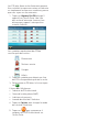
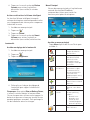
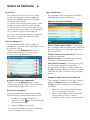
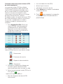
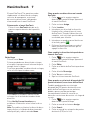
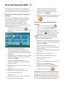
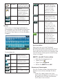
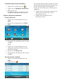
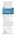
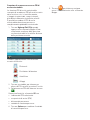
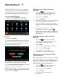
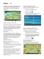
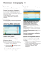
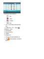
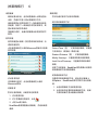
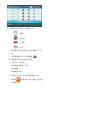
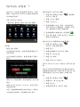
Main Menu
The Main Menu screen is the RoadMate’s
central hub of activity, containing icons
for all of the receiver’s major functions.
Accessing the Main Menu
Tap Menu from the Map screen to access:
Address Enter an address as a
route destination.
Points of
Interest
Select a Point of
Interest (POI) from
a list of preloaded
locations as a
destination.
Previous List of your most
recently visited
destinations, allowing
you to quickly select
one to route to again.
Intersection Create a route to an
intersection of two
streets.
City Center Create a route to the
geographical center of
a city.
Current
Location
Displays information
about your position,
including:
• Street name
• Names of streets
around you
• Lat/Long
information for
your position
Coordinates Enter Coordinates for
Routing.
Back Access the Map screen.

Address Book Access the Address
Book to save addresses
and destinations.
Settings Displays Settings
menu, which can
be used to access
functions for
customizing your
RoadMate receiver.
Satellite
Status
Graphic display of the
strength of satellite
signals being received.
Battery Level Graphic display of the
current battery level.
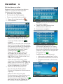
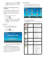
Keypad
The keypad is the most common method for
entering data into your RoadMate receiver.
Understanding the keypad while entering an
address is important for use of your RoadMate.
Keypad Overview
Backspace Moves the cursor one
position backwards, or
deletes the preceding
character.
Shift Shifts between
uppercase and
lowercase characters.
Space Inserts a space at the
cursor position.
Numeric Displays a numeric
keypad.
Symbols Displays available
symbols.
Previous Previous destination
list (Enter City only)
When entering a city,
this list displays cities
previously entered.
Tap on a city from the
displayed list to select
that city.
Zip Code (Enter City only)
Displays a numeric
keypad to quickly enter
a city’s zip code.
List (Enter City only) Press
the List button while
entering a city to
display a list of cities
beginning with the
characters you have
entered.
Accept (Entering City) Accepts
the suggested city
displayed in the data
field.
(Entering street)
Displays a list of
streets beginning with
the characters entered.
Selecting From List
When a list of items found in the database are
displayed, use the arrows on the right to move
the list up and down and tap on the desired
item in the list to continue.
Selecting QWERTY or ABC Keyboard
1. Access the Main Menu.
2. Tap .
3. Tap Keyboard.
4. Select QWERTY or ABC.
Notes on Entering Data
If you have trouble getting desired results,
follow these tips:
• Check to see if the name of a location
contains apostrophes and hyphens if you
do not see the POI or street name you are
looking for in the list.
• The more characters you enter, the smaller
the list of possible options is from which to
choose.

• You cannot use accented letters when
entering a street or city name. You can
enter city and streets names using only
standard characters.
QuickSpell
As letters are entered for a city or street, the
Quickspell feature checks the database for
cities or streets that begin with the letters
entered. Any letters that cannot be used to
spell a city or street name are greyed out.
Smart City Search
The Smart City Search feature attempts to
predict the city you are looking for based on
your position and cities you’ve gone to before.
Whenever entering or searching for an
address, the Enter City Name keyboard is
displayed first.
As letters are entered, Quickspell checks
the database for cities beginning with the
letters entered. Keys that don’t spell a city in
the database are greyed out, and Smart City
Search displays a suggested city in the text
field.
Tap the button to continue when the city is
correct.
Tapping the button displays a list of
cities that begin with the letters entered.

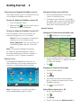
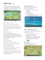
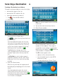
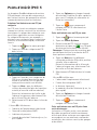
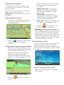
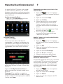
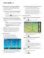
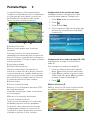
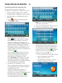
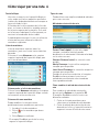
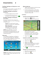
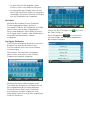
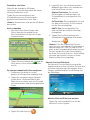
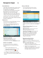
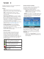
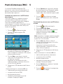
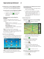
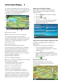
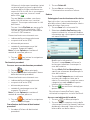
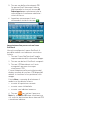
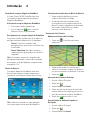
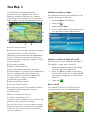
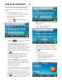
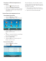
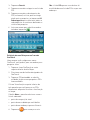
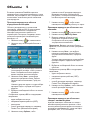
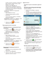
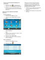
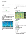
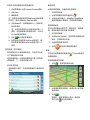
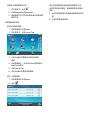
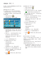
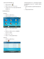
Map Screen 3
The Map screen is often used when you’re
following a route or just traveling around a
city, and will likely be displayed in one of two
unique modes: normal and routing.
A Your Current Location
B Turn instructions for next maneuver
Tap to display the maneuver list (available
only when routing). Distance and road name
for the next maneuver. Tap to repeat last voice
instruction.
C Speed limit
D Information Display
Displays speed, time of day, elevation,
compass direction. While routing, it can also
display distance to destination, estimated time
of arrival (ETA), and time remaining. Tap on the
information field to change.
E Zoom in/out
F Access Main Menu
G Access list of Highway Exit POIs
Available only while on a highway/freeway.
H Access Volume controls
I Access One Touch menu
Provides instant access to your saved search
criteria and favorite destinations.
Your position and the time are shown on the
map. As you travel, your position is updated,
giving you a clear view of your position and
surrounding streets.
Setting the Map Options
You can customize your map display
preferences in Settings.
1. Tap Menu from the Map screen.
2. Tap .
3. Tap the Map button.
4. Use the Map Options screen to customize
your map/display preferences.
Setting the Map Modes (2D or 3D)
The map is normally displayed in 3D mode.
To set the map to 2D mode:
1. Tap anywhere on the Map screen.
Additional controls appear.
2. Tap 2D to switch the map to 2D mode
from 3D mode, or tap 3D to switch the
map to 3D mode from 2D mode.
3. Tap .
3D Landmarks
3D Landmarks offer visualization for
architectural landmarks.
B
C
D
E
F
G
H
A
I

Setting Zoom Levels
As you zoom out in 3D, the display will switch
to 2D at higher zoom levels.
Tap + or - at the bottom of the Map screen to
set the desired zoom level.
Note: Zoom levels are limited in 3D mode.
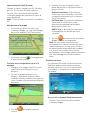
Panning on the Map
1. Slide your finger or a stylus across the
Map screen. The map screen changes to
Pan mode.
2. Tap when you’re finished, and the
map returns to your current position.
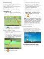
Routing to a Panned Position
1. Pan the map until the location you want to
route to is displayed.
2. Tap on the map at the point you want to go
to. A red push pin, along with information
about the point chosen, will be displayed
at the top of the screen.
3. Tap in the top left corner.
4. Define what to do with this new route
point if an active route already exists:
Replace Destination: The next destination
is cleared and replaced with the one
selected from the Pan screen.
Go There Now: The selected location is
inserted in the route as an intermediate
destination before the next destination.
Add To Trip: the selected destination is
added to the end of the current trip.
5. Tap to return to the Map screen and
begin navigating.
Note: If the selected position doesn’t match
an existing street address (i.e. the destination
is not along a road or street that is stored in
the map database), you will be stopped on
the road closest to your destination, and a
dashed line to your final destination will be
displayed on the map.
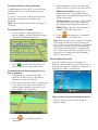
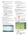
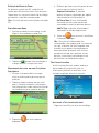
Current Location Screen
The Current Location screen displays the
approximate address of your current position,
the next and previous intersections, your
latitude, longitude, heading and elevation.
Accessing the Current Location Screen
Tap the Current Position icon from the Map
screen.

Saving Your Current Location to Your Address
Book
1. Tap on the Current Position icon from the
Map screen.
2. Tap Save.
3. Edit information.
Note: If you want to save this location to the
OneTouch menu and the address book, check
the Add to OneTouch box.
4. Tap the Name field and use the keypad to
enter a name for the Address Book entry.
Note: Tap List Categories to select a
category for this address. New categories
can be added from the Select Category
from List screen by tapping +Add.
5. Tap to confirm address details.
6. Assign this entry to a button for your
OneTouch menu if you saved this point to
the OneTouch menu.
Maneuver List (Itinerary)
The Maneuver List is accessed from the Map
screen, and is available only when routing.
Each line in the Maneuver List provides details
about the maneuvers in the order that they are
to be made, with the next maneuver at the top.
Accessing the Maneuver List
Tap the Maneuver icon in the top left corner
of the Map screen when actively on a route.
Avoiding a Maneuver
This feature modifies the route to possibly
avoid a particular maneuver.
1. Access the Maneuver List.
2. Tap next to the maneuver you want to
avoid.
3. Tap Yes to confirm. The Magellan
RoadMate receiver recalculates the route
and returns you to the Map screen.
Changing Route Options
You can change how a route is computed
by Fastest Time, Shortest Distance, Mostly
Freeways, or Least Use of Freeways.
1. Access the Maneuver List.
2. Tap Route Options. The four types of
routes are displayed with the computed
time.
3. Tap on the desired route option.
4. Tap to begin routing.
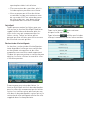
Volume
You can adjust or mute the volume from the
Map screen or from > Sound.
Changing the Volume from the Map Screen
1. Tap . Additional controls appear.
2. Tap on the Speaker button to mute the
volume, or tap + or - icons to change the
volume levels.
3. Tap .
When muted, a red line appears across
the speaker icon. Tap again to unmute
the volume.

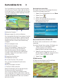
Selecting a Destination 4
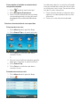
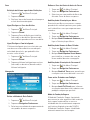
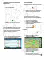
Creating a Destination to an Address
To begin creating an address, enter the city by:
• entering the name of the city
• entering the ZIP code for the city
• selecting a previously used city.
1. Tap from the Main Menu.
2. Enter City:
You can do this in three ways:
Tap to select the city from the list of
previous cities.
Use the keyboard to enter the first few
characters of any significant word in the
city name to select a new city. If the city
you’re searching for appears in the top
field, tap on the city name or .
Tap List button to bring up a list of
cities that begin with the characters you
entered. Tap to select the city from the
list.
Tap Zip Code to switch to the numeric
keyboard and enter the ZIP code. Tap to
bring up a list of cities with the zip code
entered.
3. Enter the Street name.
With the city selected, the keyboard will
be displayed, prompting you for the street
name.
Use the keyboard to enter the street
name. Enter the first few characters of
any word in the street name, and tap
or continue entering characters until the
list of streets is displayed.
Note: You do not need to enter accented
characters.
4. Tap on the street name from the list.
5. Enter Street number:
Use the keyboard to enter the street
number for the address. The range of
acceptable street numbers is displayed
before you start typing. Tap when the
street number is complete.
The GO screen appears with:
• address of the selected location
• the estimated time of arrival (ETA)
distance to travel
• routing method (e.g. Fastest Time).

Tap Options to change routing method.
Tap to preview the route.
6. Tap to begin routing on the Map
screen.
Note: To use a destination later, tap Save
(before tapping GO) to save it in your
Address Book or in the OneTouch menu.
Tips on Entering Addresses Quickly
• When you are entering the name of a city
or a street, only characters that appear in
possible search results are displayed. The
other characters are grayed out.
• Tap List after a couple of letters when
entering city names or street names, as
items that contain the specified characters
are listed.
• Search by ZIP codes to narrow the number
of matching cities to (usually) four or fewer.
Intersections
Creating a Destination to an Intersection
An intersecting street can pinpoint the location
when you don’t know the street number.
1. Tap from the Main Menu.
2. Enter City. To do this:
• Use the keyboard to enter the first few
characters of any significant word in
the city name to enter a new city. Tap
on the city name or if the city you
are searching for appears in the top
field.
• Tap Previous to select the city from
the list of previous cities.
• Tap List to display a list of cities that
begin with the characters you entered.
Tap to select the city from the list.
• Tap Zip Code to switch to the numeric
keyboard and enter the ZIP code. Tap
to bring up a list of cities with this zip
code.
3. Enter the Street name:
With the city selected, the keyboard will
be displayed, prompting you to enter the
street name.
Use the keyboard to enter the street
name. Enter the first few characters of
any word in the street name and tap
or continue entering characters until the
list of streets is displayed.
Note: You do not need to enter accented
characters.
Tap on the street name from the list.
4. Enter the second street name the same
way as you entered the first street.
A screen appears with:
• address of the selected location
• estimated time of arrival (ETA)
• distance to travel
• routing method (e.g. Fastest Time).
Note: Tap Options to change the routing
method.
5. Tap to begin routing on the Map
screen.
City Centers
Creating a Destination to a City Center
City Center lets you select any city on the map
as your destination, which is useful when
you want to go to a city without selecting any
specific address.
Note: A route to a city center uses the
geographical center of the city as the
destination point.
1. Tap from the Main Menu.
2. Enter City:
Tap Previous to select the city from the
list of previous cities.
Use the keyboard to enter the first few
characters of any significant word in the
city name to select a new city. If the city
you are searching for appears in the top
field, tap on the city name or .

Tap on the List button to access a list of
cities that begin with the characters you
entered. Tap to select a city from the list.
Tap the Zip Code button to switch to the
numeric keyboard and enter the ZIP code.
Tap to bring up a list of cities with the zip
code entered.
A screen appears with:
• address of the selected location
• estimated time of arrival (ETA)
• distance to travel
• routing method (e.g. Fastest Time).
Note: Tap Options to change the routing
method.
3. Tap to begin navigating on the Map
screen.
Previous Destinations
Routing to a Previous Destination
1. Tap from the Main Menu.
2. Select a destination from the list of
previous destinations.
A screen appears with:
• address of the selected location
• estimated time of arrival (ETA)
• distance to travel
• routing method (e.g. Fastest).
Note: Tap Options to change the routing
method.
3. Tap to begin navigating on the Map
screen.
Clearing the list of Previous Destinations
1. Access the list of Previous Destinations.
2. Tap Delete All.
3. Tap Yes to confirm the deletion and clear
the list.
Address Book
Saving a Destination to Your Address Book
Whenever you create a destination, you can
save the destination to your address book
before beginning the route.
1. Tap Save on the Go screen.
2. Select Add to OneTouch when the Edit
Information screen is displayed to save
this location to the OneTouch menu.
Edit information:
Tap the Name field and use the keyboard
to enter a name for the address book
entry.
Tap Work, Cell or Home phone to specify
a phone number for the address book
entry.
Tap List Categories to display a list
of categories you’ve created for your
address book. If necessary, create a new
category by tapping + Add at the bottom
of the screen.
3. Tap to confirm the details for this
address.
To save this to the OneTouch menu, you will
be asked to assign it to a OneTouch button.
Accessing an Address in Your Address Book
1. Tap from the Main Menu.
2. Tap the top left corner of the screen
to easily find the desired address by
narrowing the list by the first letter of the
address book entries.

Routing to an Address in Your Address Book
1. Access the address record from your
address book.
2. Tap on the desired address book
entry. A screen appears with:
• address of the selected location
• estimated time of arrival (ETA)
• distance to travel
• routing method (e.g. Fastest Time).
Note: Tap Options to change the routing
method.
3. Tap to begin navigating on the Map
screen.

Points of Interest (POI) 5
The RoadMate receiver has preloaded POIs,
such as restaurants and gas stations, that can
be used as destinations for routes.
Creating a Route to a POI by Category
POIs are categorized into unique categories
like gas stations and tourist attractions.
Most categories are further organized into
subcategories. Restaurants, for example, have
several subcategories for Chinese food, fast
food, or other favorites.
1. Tap from the Main Menu.
2. Tap one of the POI categories in the list.
3. Tap one of the POI subcategories (if any)
in the list to narrow the search. POIs near
your current position are displayed.
4. Tap Near... for different search criteria
(Near Current Position, City, or Address).
Enter city or address information when
you select Near City or Near Address.
5. Select the desired POI from the POIs list.
The GO screen appears with:
• address of the selected location
• estimated time of arrival (ETA)
• distance to travel
• routing method (e.g. Fastest Time).
6. Tap Options to change the routing method
(Fastest Time, Shortest Distance, Mostly
Freeways, or Least Use of Freeways).
7. Tap to begin navigating to the
selected POI on the Map screen.
Creating a Route to a POI by Name
1. Tap from the Main Menu.
2. Tap Search By Name.
3. Enter the name of the POI to be used as
the destination and tap . POIs near
your current position are displayed
Note: Enter as many characters as possible
to make it easier to find the exact POI you are
searching for.
4. Tap Near for different search criteria
(Near Current Position, City, or Address).
Enter city or address information when
you select Near City or Near Address.
5. Select the desired POI from the POIs list.
The GO screen appears with
• address of the selected location
• estimated time of arrival (ETA)
• distance to travel
• routing method (e.g. Fastest Time).
6. Tap Options to change the routing
method.
7. Tap to begin navigating on the Map
screen.
Creating a Route to a Highway Exit POI
The Highway Exit POIs function lets you access
commonly used POIs near an exit you’re
approaching while travelling on a highway,
such as restaurants, gas stations, car repair
facilities and hotels.
Freeway Exit POIs can be accessed while on
a route or just driving, as long as you are on a
freeway.
1. Tap Highway Exit POIs when it appears
on the Map screen. A list of upcoming
freeway exits and their distance from your
current position appears.

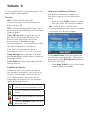
Symbols represent service POIs near the exits:
Restaurants
Gas Stations
Car Repair
Accommodations
2. Tap a symbol to get a list of related POIs
near the exit.
3. Select a POI from the list, and tap .
The GO screen appears with
• address of the selected POI
• estimated time of arrival (ETA)
• distance to travel
• routing method.
4. Tap Options to change the routing
method.
5. Tap to begin navigating to the
selected POI on the Map screen.
A página está carregando...
A página está carregando...
A página está carregando...
A página está carregando...
A página está carregando...
A página está carregando...
A página está carregando...
A página está carregando...
A página está carregando...
A página está carregando...
A página está carregando...
A página está carregando...
A página está carregando...
A página está carregando...
A página está carregando...
A página está carregando...
A página está carregando...
A página está carregando...
A página está carregando...
A página está carregando...
A página está carregando...
A página está carregando...
A página está carregando...
A página está carregando...
A página está carregando...
A página está carregando...
A página está carregando...
A página está carregando...
A página está carregando...
A página está carregando...
A página está carregando...
A página está carregando...
A página está carregando...
A página está carregando...
A página está carregando...
A página está carregando...
A página está carregando...
A página está carregando...
A página está carregando...
A página está carregando...
A página está carregando...
A página está carregando...
A página está carregando...
A página está carregando...
A página está carregando...
A página está carregando...
A página está carregando...
A página está carregando...
A página está carregando...
A página está carregando...
A página está carregando...
A página está carregando...
A página está carregando...
A página está carregando...
A página está carregando...
A página está carregando...
A página está carregando...
A página está carregando...
A página está carregando...
A página está carregando...
A página está carregando...
A página está carregando...
A página está carregando...
A página está carregando...
A página está carregando...
A página está carregando...
A página está carregando...
A página está carregando...
A página está carregando...
A página está carregando...
A página está carregando...
A página está carregando...
A página está carregando...
A página está carregando...
A página está carregando...
A página está carregando...
A página está carregando...
A página está carregando...
A página está carregando...
A página está carregando...
A página está carregando...
A página está carregando...
A página está carregando...
A página está carregando...
A página está carregando...
A página está carregando...
A página está carregando...
A página está carregando...
A página está carregando...
A página está carregando...
A página está carregando...
A página está carregando...
A página está carregando...
A página está carregando...
A página está carregando...
A página está carregando...
A página está carregando...
A página está carregando...
A página está carregando...
A página está carregando...
A página está carregando...
A página está carregando...
A página está carregando...
A página está carregando...
A página está carregando...
A página está carregando...
A página está carregando...
A página está carregando...
A página está carregando...
A página está carregando...
A página está carregando...
A página está carregando...
A página está carregando...
A página está carregando...
A página está carregando...
A página está carregando...
A página está carregando...
A página está carregando...
A página está carregando...
A página está carregando...
A página está carregando...
A página está carregando...
A página está carregando...
A página está carregando...
A página está carregando...
A página está carregando...
A página está carregando...
A página está carregando...
A página está carregando...
A página está carregando...
A página está carregando...
A página está carregando...
A página está carregando...
A página está carregando...
A página está carregando...
A página está carregando...
A página está carregando...
A página está carregando...
A página está carregando...
A página está carregando...
A página está carregando...
A página está carregando...
A página está carregando...
A página está carregando...
A página está carregando...
A página está carregando...
A página está carregando...
A página está carregando...
A página está carregando...
A página está carregando...
A página está carregando...
A página está carregando...
A página está carregando...
A página está carregando...
A página está carregando...
A página está carregando...
A página está carregando...
A página está carregando...
A página está carregando...
A página está carregando...
A página está carregando...
A página está carregando...
A página está carregando...
A página está carregando...
A página está carregando...
A página está carregando...
A página está carregando...
A página está carregando...
A página está carregando...
A página está carregando...
A página está carregando...
A página está carregando...
A página está carregando...
A página está carregando...
A página está carregando...
A página está carregando...
A página está carregando...
A página está carregando...
A página está carregando...
A página está carregando...
A página está carregando...
A página está carregando...
A página está carregando...
A página está carregando...
A página está carregando...
A página está carregando...
A página está carregando...
A página está carregando...
A página está carregando...
A página está carregando...
A página está carregando...
A página está carregando...
A página está carregando...
A página está carregando...
A página está carregando...
A página está carregando...
A página está carregando...
A página está carregando...
A página está carregando...
A página está carregando...
A página está carregando...
A página está carregando...
A página está carregando...
A página está carregando...
A página está carregando...
A página está carregando...
A página está carregando...
A página está carregando...
A página está carregando...
A página está carregando...
A página está carregando...
A página está carregando...
A página está carregando...
A página está carregando...
A página está carregando...
A página está carregando...
A página está carregando...
A página está carregando...
A página está carregando...
A página está carregando...
A página está carregando...
A página está carregando...
A página está carregando...
A página está carregando...
A página está carregando...
A página está carregando...
A página está carregando...
A página está carregando...
A página está carregando...
A página está carregando...
A página está carregando...
A página está carregando...
A página está carregando...
A página está carregando...
A página está carregando...
A página está carregando...
A página está carregando...
A página está carregando...
A página está carregando...
A página está carregando...
A página está carregando...
A página está carregando...
A página está carregando...
A página está carregando...
A página está carregando...
A página está carregando...
A página está carregando...
A página está carregando...
A página está carregando...
A página está carregando...
A página está carregando...
A página está carregando...
A página está carregando...
A página está carregando...
A página está carregando...
A página está carregando...
A página está carregando...
A página está carregando...
A página está carregando...
A página está carregando...
A página está carregando...
A página está carregando...
A página está carregando...
A página está carregando...
A página está carregando...
A página está carregando...
A página está carregando...
A página está carregando...
-
 1
1
-
 2
2
-
 3
3
-
 4
4
-
 5
5
-
 6
6
-
 7
7
-
 8
8
-
 9
9
-
 10
10
-
 11
11
-
 12
12
-
 13
13
-
 14
14
-
 15
15
-
 16
16
-
 17
17
-
 18
18
-
 19
19
-
 20
20
-
 21
21
-
 22
22
-
 23
23
-
 24
24
-
 25
25
-
 26
26
-
 27
27
-
 28
28
-
 29
29
-
 30
30
-
 31
31
-
 32
32
-
 33
33
-
 34
34
-
 35
35
-
 36
36
-
 37
37
-
 38
38
-
 39
39
-
 40
40
-
 41
41
-
 42
42
-
 43
43
-
 44
44
-
 45
45
-
 46
46
-
 47
47
-
 48
48
-
 49
49
-
 50
50
-
 51
51
-
 52
52
-
 53
53
-
 54
54
-
 55
55
-
 56
56
-
 57
57
-
 58
58
-
 59
59
-
 60
60
-
 61
61
-
 62
62
-
 63
63
-
 64
64
-
 65
65
-
 66
66
-
 67
67
-
 68
68
-
 69
69
-
 70
70
-
 71
71
-
 72
72
-
 73
73
-
 74
74
-
 75
75
-
 76
76
-
 77
77
-
 78
78
-
 79
79
-
 80
80
-
 81
81
-
 82
82
-
 83
83
-
 84
84
-
 85
85
-
 86
86
-
 87
87
-
 88
88
-
 89
89
-
 90
90
-
 91
91
-
 92
92
-
 93
93
-
 94
94
-
 95
95
-
 96
96
-
 97
97
-
 98
98
-
 99
99
-
 100
100
-
 101
101
-
 102
102
-
 103
103
-
 104
104
-
 105
105
-
 106
106
-
 107
107
-
 108
108
-
 109
109
-
 110
110
-
 111
111
-
 112
112
-
 113
113
-
 114
114
-
 115
115
-
 116
116
-
 117
117
-
 118
118
-
 119
119
-
 120
120
-
 121
121
-
 122
122
-
 123
123
-
 124
124
-
 125
125
-
 126
126
-
 127
127
-
 128
128
-
 129
129
-
 130
130
-
 131
131
-
 132
132
-
 133
133
-
 134
134
-
 135
135
-
 136
136
-
 137
137
-
 138
138
-
 139
139
-
 140
140
-
 141
141
-
 142
142
-
 143
143
-
 144
144
-
 145
145
-
 146
146
-
 147
147
-
 148
148
-
 149
149
-
 150
150
-
 151
151
-
 152
152
-
 153
153
-
 154
154
-
 155
155
-
 156
156
-
 157
157
-
 158
158
-
 159
159
-
 160
160
-
 161
161
-
 162
162
-
 163
163
-
 164
164
-
 165
165
-
 166
166
-
 167
167
-
 168
168
-
 169
169
-
 170
170
-
 171
171
-
 172
172
-
 173
173
-
 174
174
-
 175
175
-
 176
176
-
 177
177
-
 178
178
-
 179
179
-
 180
180
-
 181
181
-
 182
182
-
 183
183
-
 184
184
-
 185
185
-
 186
186
-
 187
187
-
 188
188
-
 189
189
-
 190
190
-
 191
191
-
 192
192
-
 193
193
-
 194
194
-
 195
195
-
 196
196
-
 197
197
-
 198
198
-
 199
199
-
 200
200
-
 201
201
-
 202
202
-
 203
203
-
 204
204
-
 205
205
-
 206
206
-
 207
207
-
 208
208
-
 209
209
-
 210
210
-
 211
211
-
 212
212
-
 213
213
-
 214
214
-
 215
215
-
 216
216
-
 217
217
-
 218
218
-
 219
219
-
 220
220
-
 221
221
-
 222
222
-
 223
223
-
 224
224
-
 225
225
-
 226
226
-
 227
227
-
 228
228
-
 229
229
-
 230
230
-
 231
231
-
 232
232
-
 233
233
-
 234
234
-
 235
235
-
 236
236
-
 237
237
-
 238
238
-
 239
239
-
 240
240
-
 241
241
-
 242
242
-
 243
243
-
 244
244
-
 245
245
-
 246
246
-
 247
247
-
 248
248
-
 249
249
-
 250
250
-
 251
251
-
 252
252
-
 253
253
-
 254
254
-
 255
255
-
 256
256
-
 257
257
-
 258
258
-
 259
259
-
 260
260
-
 261
261
-
 262
262
-
 263
263
-
 264
264
-
 265
265
-
 266
266
-
 267
267
-
 268
268
-
 269
269
-
 270
270
-
 271
271
-
 272
272
-
 273
273
-
 274
274
-
 275
275
-
 276
276
-
 277
277
-
 278
278
-
 279
279
-
 280
280
-
 281
281
-
 282
282
-
 283
283
-
 284
284
-
 285
285
-
 286
286
-
 287
287
-
 288
288


Magellan roadmate 5620-LM Manual do usuário
- Categoria
- Navegadores
- Tipo
- Manual do usuário
- Este manual também é adequado para
em outras línguas
- español: Magellan roadmate 5620-LM Manual de usuario
- français: Magellan roadmate 5620-LM Manuel utilisateur
- italiano: Magellan roadmate 5620-LM Manuale utente
- English: Magellan roadmate 5620-LM User manual
- русский: Magellan roadmate 5620-LM Руководство пользователя
- Deutsch: Magellan roadmate 5620-LM Benutzerhandbuch
Artigos relacionados
-
Magellan Maestro 4250 - Automotive GPS Receiver User manual
-
-
-
-
-
Outros documentos
-
Bushnell BackTrack HuntTrack Manual do usuário
-
Teasi One 4 Guia rápido
-
Takara GPS GP83CAV Manual do proprietário
-
Dometic Roadmate 230 Instruções de operação
-
Kenwood KNA-G431 Manual do usuário
-
Datalogic Magellan 1100i Quick Reference Manual
-
Mio Digi Walker C510 Guia rápido
-
-
Kapsys Kapten NG Guia de usuario
-