3B SCIENTIFIC 1017593 [U70010] Manual do proprietário
- Tipo
- Manual do proprietário

(U70010)
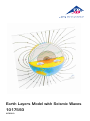
Earth Layers Model with Seismic Waves
1017593

2

®
3
Die Erforschung der Erde
Die Erforschung der Erde mit ihrer komplexen Dynamik ist Aufgabe der Geowissenschaften. Was man über
den Aufbau und die Zusammensetzung das Innere der Erde weiß, haben Geologen und Geophysiker mit
ganz verschiedenen Methoden zusammengetragen. Seismische Wellen verraten ihren inneren Schalenbau
und Experimente mit Stoßwellen die chemische Zusammensetzung. Neben der Seismik gibt es aber noch
andere geophysikalische Daten, die uns Aufschlüsse über den inneren Aufbau der Erde liefern. Neben der
Vermessung der Schwerkraft (Gravimetrie) liefert auch das Magnetfeld der Erde wichtige Hinweise.
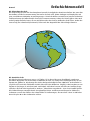
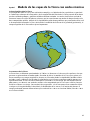
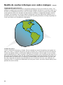
Die Gestalt der Erde
Die Erde hat einen Durchmesser von ca. 12.750 km. Sie ist aber nicht genau kugelförmig, sondern an
den Polen abgeplattet. Der Grund dafür ist Rotation der Erde. Sie erzeugt eine zentrifugale Kraft, die am
Äquator am größten ist. Hier beträgt die relative Drehgeschwindigkeit etwa 1600 km/h. An den Polen ist
sie gleich null. Durch die Fliehkräfte wird die Erde also leicht deformiert. Folglich ist der Durchmesser am
Äquator 43 km länger als zwischen Nord- und Südpol. Außerdem hat man mit Hilfe von Satelliten festge-
stellt, dass die Erde nicht kugelrund ist, sondern – übertrieben ausgedrückt – eher einer Kartoffel gleicht.
Diese Abweichungen entstehen durch unregelmäßige Dichte- und Massenverteilungen im Erdinneren.
So kommt es unter dem Einfluss des Schwerefeldes zu Verformungen, die von minus 110 m im Indischen
Ozean bis plus 90 m über Südostasien reichen.
Deutsch Erdschichtenmodell

®
4
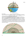
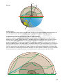
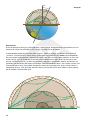
Erdachse:
Die Rotationachse der Erde verläuft durch Nord- und Südpol. Gegenüber der Ebene der Erdbewegung um
die Sonne ist die Achse um etwas mehr als 23° geneigt, so wie bei unserem Modell.
Die Erforschung des Erdinneren mit seismischen Wellen:
Da Geologen und Geophysiker auch mit den tiefsten Bohrungen von 10.000 m Teufe die Erdkruste nur
„ankratzen“ können, müssen sie den inneren Aufbau anhand von geophysikalischen Beobachtungen indi-
rekt berechnen. Der Schlüssel dazu sind seismische Wellen, die von Erdbeben erzeugt werden. Es gibt zwei
Arten von Wellen: Druck- oder Kompressionswellen und Scherwellen. Die Erbebenwellen breiten sich wie
Schallwellen aus. Im Erinnern werden sie durch die unterschiedliche Dichte gebrochen, oder an scharfen
Diskontinuitäten reflektiert. An den Seismischen Stationen, die es überall auf der Erde gibt, werden dann
die Laufzeiten der Erbebenwellen gemessen, woraus der Aufbau der Erde berechnet werden kann. Mit Hilfe
der Scherwellen kann man flüssige und feste Zonen unterscheiden, weil Flüssigkeiten nur Druckwellen
übertragen. Damit ist klar, dass der äußere Kern flüssig sein muss.
23,5° Deutsch

®
5
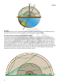
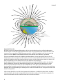
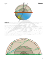
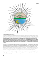
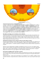
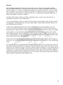
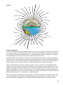
Auf unserem Modell sehen wir, ausgehend vom Erbebenherd (roter Punkt) sechs mögliche Verläufe
von Erbebenwellen. Wäre die Erde völlig homogen, würden die Wellen gerade hindurch verlaufen. In
Wirklichkeit besteht die Erde aber aus verschiedenen Schichten mit unterschiedlichen Materialien und
Temperaturen, in denen sich die Kompressionswellen (P) und Schwerwellen (S) mit unterschiedlichen
Geschwindigkeiten ausbreiten. Die Wellen werden gebrochen, gekrümmt oder reflektiert.
(1) Die untere Welle trifft senkrecht auf die Schalen im Erdinneren und läuft schnurgerade durch die Erde.
Die Laufzeit beträgt dabei von einem Ende zum anderen 20 min.
(2) Darüber ist ein Strahl, der beim Eintritt in den Kern nach unten gebrochen wird, gerade noch am
Inneren Kern vorbeiläuft, und beim Austritt in den Mantel erneut gebrochen wird. Wegen dieser zweima-
ligen Brechung taucht die Welle viel weiter unten (südlich) auf, als vom Herd aus berechnet.
(3) Dieser Strahl wird wieder an der Kern-Mantel-Grenze gebrochen und im weiteren Verlauf nochmals
reflektiert, beim Austritt wieder gebrochen, so dass er an gleicher Stelle an der Oberfläche austritt wie
Welle (2), allerdings mit längerer Laufzeit. Die Scherwelle (blau schraffiert), endet am Erdkern, weil dieser
flüssig ist.
(4) Diese P- und S-Wellen laufen gerade noch am Erdkern vorbei und treten bei einem Winkel von 105° aus.
Ab diesem Winkel beginnt für beide Wellen eine Schattenzone, weil die S-Wellen den flüssigen Kern nicht
durchdringen können und die P-Wellen nach unten gebrochen werden (siehe 2). Die Schattenzone der
Kompressionswellen endet bei ca. 140° (Punkt 2/3).
(5) Dieser Strahl einer Kompressionswelle wird so gekrümmt, dass er nach einer Laufzeit von 9 min wieder
an die Erdoberfläche kommt, und hier teilweise reflektiert wird, um nach 105° vom Erdbebenherd erneut
an die Oberflache zu kommen.
(6) Die rote Wellenlinie stellt die Oberflächenwellen dar, die rund um die Erde laufen. Am Austrittspunkt
(3/4) laufen zwei zusammen. Beide haben unterschiedliche Laufzeiten, denn die Wellen, die von „unten“
kommen, haben einen längeren Weg hinter sich. Außerdem breiten sich Kompressions-Wellen schneller
aus als die Scherwellen. In unserem Modell würden die P-Wellen etwa 20 Minuten früher eintreffen als die
S-Wellen. Wenn man die Seismogramme und Laufzeitendifferenzen mehrerer Erdbebenstationen mitei-
nander vergleicht, kann man leicht die geographische Lage des Epizentrums ermitteln. Bei der seismischen
Tomographie werden die Laufzeiten vieler Erdbeben dazu verwendet, um dreidimensionale Bilder des
Erdinneren zu berechnen.
Deutsch

®
6
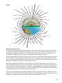
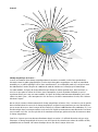
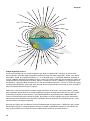
Magnetfeld der Erde:
Die Erde ist von einem Magnetfeld umgeben, das in seiner Struktur dem eines großen Stabmagneten
ähnelt. So gibt es neben den geographischen Polen auch zwei magnetische Pole. Beide fallen aber nicht
zusammen. Der magnetische Südpol liegt gegenwärtig 5° südlich des Nordpols, und in den letzten 200
Jahren ist er über 1000 km vom nördlichen Kanada nach Norden in das Polarmeer gewandert.
Auf unserem Modell verlaufen die Feldlinien ideal bogenförmig, in der Natur gilt da aber nur für die
Erdoberfläche. In der Ionosphäre ab 80 km Höhe (was auf unserem Modell noch nicht einmal 2 mm sind),
werden die Feldlinien durch den Sonnenwind stark verzerrt. Auf der Sonnenseite werden sie dicht an die
Erde herangedrückt, auf der Nachtseite weit in den Weltraum hinausgezogen.
Wie das Magnetfeld genau entsteht, ist noch nicht richtig verstanden. Jedenfalls steckt in der Erde kein
großer Stabmagnet, sondern das Magnetfeld wird durch eine Art Dynamo im Erdkern immer wieder
neu erzeugt. Im äußeren Eisenkern, in etwa 3000 Kilometer Tiefe, gibt es einen Wärmefluss in den
Gesteinsmantel. Dadurch setzt sich das flüssige Eisen in Bewegung, ähnlich wie Wasser in einem geheizten
Kochtopf. Diese schraubenförmigen Strömungen des elektrisch leitenden Eisens erzeugen dann Strom und
damit das Magnetfeld.
Vieles deutet darauf hin, dass die dieser Dynamo seit mindestens 3,5 Milliarden Jahren läuft, allerdings
nicht regelmäßig. So hat sich das Magnetfeld der Erde Hunderte oder gar Tausende Male umgepolt, ver-
mutlich eine Reaktion auf die chaotische Natur dieser Ströme im Erdkern.
Deutsch

7
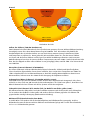
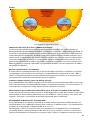
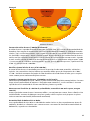
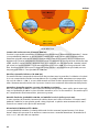
4700 °C, 3400 kbar
1500 °C, 150 kbar
1700 °C, 275 kbar
3500 °C, 1450 kbar
4900 °C, 3650 kbar
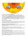
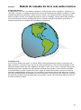
Schalenbau der Erde
Aufbau der Erdkerns (7000 km Durchmesser):
Vom Erdmantel wird der Erdkern durch eine scharfe Grenze getrennt, die man Wichert-Oldham-Gutenberg-
Unstetigkeit nennt. Diese Kern-Mantel-Grenze liegt bei 2900 km Tiefe. Hier ändert sich plötzlich die
Geschwindigkeit der seismischen Wellen, was nur durch einen enormen Sprung in Konsistenz, Dichte
und Temperatur zu erklären ist. Heute gehen die Wissenschaftler davon aus, dass der Innere Erdkern
aus festen und der Äußere Erdkern aus flüssigen Eisen-Nickel-Verbindungen bestehen. Nach neuesten
Modellrechnungen herrschen im Inneren Erdkern Temperaturen von etwa 4900 °C und ein Druck von 3650
kbar. Der fast doppelt so dicke äußere Erdkern ist nur geringfügig kälter, nämlich 4700 °C bei einem Druck
von 3400 kbar.
Mesosphäre (Unterer Erdmantel, 670-2900 km):
Der Untere Erdmantel wird von Hochdruckmineralen wie Perowskit, Stichovit und Spinell aufgebaut.
Seine seismischen Eigenschaften lassen darauf schließen, dass er trotz einer Temperatur von 1500°C bis
3500° weitgehend fest ist. Im Erdmantel kommt es durch die ständige Wärmeabgabe aus dem Kern zu
Wärmeströmen, in denen man den Motor für die Bewegung der Erdplatten vermutet.
Asthenosphäre (Oberer Erdmantel, 270-400 km mächtig, orange):
Unterhalb einer Tiefe von etwa 100 km wird das Gestein meist so plastisch wie Knetgummi. Diese Zone
reicht bis zu einer Tiefe von 440 km und wird als Asthenosphäre, die “nicht harte Sphäre”, bezeichnet. Der
Obere Erdmantel wird aus Silikaten wie Olivin, Pyroxen und Granat aufgebaut.
Lithospährischer Erdmantel (0 bis 200 km Tiefe, im Modell 2 mm dicker, gelber Saum):
Die obersten Zone des Erdmantels ist wieder fest bildet zusammen mit der Kruste die starre Lithosphäre.
Sie ist rund um den Erdball in sieben große und mehrere kleinere Platten gegliedert. Die Platten sind
gegeneinander ständig in Bewegung (Kontinentalverschiebung)
Mohorovičič-Diskontinuität oder kurz Moho:
In 10 bis 80 km Tiefe ändern sich die Geschwindigkeiten von Erdbebenwellen sprungartig. An diese
Diskordanz hat man die Grenze zwischen Erdkruste und Erdmantel gelegt und sie nach ihrem Entdecker
Mohorovičič -Diskontinuität genannt.
Deutsch

®
8
Kruste (7-70 km mächtig, im Modell 1 mm dicker, dunkelbrauner Strich):
Der Erdball wird von einer harten Kruste bedeckt. Sie ist im Vergleich zum Gesamtradius der Erde nur so
dick wie die Schale eines Apfels. Unter den Ozeanen ist sie nur 7-10 km dick und besteht hier aus dunklen
Mineralen und Feldspat. Die Kontinentale Kruste ist im Durchschnitt 40 km mächtig und besteht aus grani-
tischen Gesteinen mit geringerer Dichte. Im Bereich der hohen Gebirge wie den Anden oder dem Himalaya
kann sie auf 70 km Dicke anschwellen.
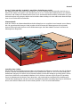
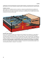
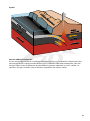
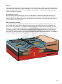
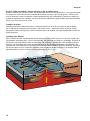
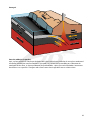
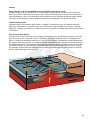
Plattentektonik
Nach der Theorie der Plattentektonik besteht die Lithosphäre aus ungefähr einem Dutzend starrer Platten,
die sich gegeneinander bewegen. Dabei ergeben sich drei Formen der Plattengrenzen: divergierende
Grenzen, konvergierende Grenzen und Transformstörungen. kAuf dem Modell sind zwei Szenarien der
Plattengrenzen dargestellt.
Deutsch
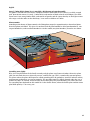
Spreading-Zone (rechts):
Hier drücken die aufsteigenden Wärmeströme des Erdmantels die Platten auseinander. Wo sich die Platten
trennen, schmilzt durch Druckentlastung das Gestein und füllt den Spalt aus. Das ist ein sich ständig wie-
derholender Vorgang. Die Stellen des Auseinander-Driftens nennen die Geologen Spreading-Zonen. Durch
intensiven Vulkanismus und ständige Erdbeben sind sie leicht zu erkennen. Meist liegen die Spreading-
Zonen als Mittelozeanische Rücken unter dem Meer. Auf Island und im Ostafrikanischen Grabensystem
verläuft diese Plattengrenze auf dem Land. Die im Modell dargestellte Spreading-Zone liegt im Pazifischen
Ozean, wo Pazifische Platte und die Nazca-Platte jährlich 17 cm weit auseinanderdriften.
Lithosphäre
Asthenosphäre
Ozeanische Kruste
Kontinentale Kruste
Temperaturabnahme im Gestein
Bewegungsrichtung
Bewegungsrichtung
Temperaturabnahme im Gestein
älteres Gestein junges Gestein älteres Gestein
junges Gestein

®
9
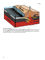
Subduktions-Zone (links):
Hier taucht eine Ozeanischen Platte unter einer anderen Ozeanischen oder einer Kontinentalen Platte
ab. Dabei entsteht zunächst eine Tiefseerinne, die sich teilweise durch Sedimente vom Festland oder
dem Inselbogen füllen kann. In einigen Hundert Kilometer Tiefe wird die abtauchende Platte an ihrer
Oberfläche wieder aufgeschmolzen. Die Magmen steigen auf und bilden dann magmatische Gürtel mit
aktiven Vulkanen.
Deutsch
Ozeanische Kruste
Lithosphäre
Asthenosphäre
Tiefseegraben
Faltengebirge
Lithosphäre
Asthenosphäre
Kontinentale
Kruste

®
English
10
Earth Layer Model with Seismic waves
Exploration of the Earth
To explore the Earth’s complex dynamics is the mission of Earth Science. Geologists and Geophysicists, using
a wide range of methods, have contributed to what we know about the structure and composition of the
Earth’s interior. Seismic waves reveal the construction of the Earth’s inner layers and shock wave experi-
ments show its chemical composition. Apart from Seismology, there are other kinds of geophysical data
that provide us with additional information on the internal make-up of the Earth. We can measure gravity
(gravimetry) to learn about the Earth, but the Earth’s magnetic fields provide us with important indicators
too.
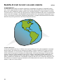
The shape of the Earth
The Earth has a diameter of approx. 12,750 km. It is, however, not perfectly round like a ball and is flat-
tened off at the Poles. This is caused by the Earth’s rotation. It creates a centrifugal force that is at its
strongest at the Equator. The relative spin velocity here is around 1,600 kmph. At the Poles it is almost
zero. Therefore, because of this centrifugal force, the Earth is slightly deformed shape-wise. Consequently,
the diameter at the equator is 43 km longer than between the North and South Poles. With the help of
Satellites, we have also learned that the Earth is not round like a ball; instead it is, to exaggerate some-
what, rather like a potato. These differences result from the irregular density and mass distribution inside
the Earth. The effect of the gravitational field leads to distortions that go from minus 110 m in the Indian
Ocean to plus 90 m across Southeast Asia.

®
Name
English
11
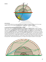
Earth’s Axis
The rotational axis of the Earth passes through the North and South Poles. In relation to the plane of the
Earth’s movement around the Sun, the axis is angled at over 23°, as demonstrated by our model.
Exploration of the inside of the Earth with Seismic Waves
Since geologists and geophysicists, even with the deepest holes, down to a depth of 10,000 m, are only real-
ly “scratching” the earth’s crust, they have to work out the Earth’s inner structure indirectly, using geophy-
sical observations. The key to this is seismic waves, which are created by earthquakes. There are two kinds
of waves: Pressure or compression waves and shear/secondary waves. Earthquake waves spread like sound
waves. Deep in the Earth’s core, they are refracted by the variations in density, or reflected on sharp discon-
tinuities. At seismic stations located all around the Earth, the duration of earthquake waves are measured,
and from this the structure of the Earth can be calculated. With the help of shear waves, a distinction can
be made between the liquid and solid zones, because liquids only propagate compression waves. This
clearly shows that the outer core must be liquid.
23,5°

®
English
12
On our model, we can see, starting from the seismic centre (red point) that there are six possible pathways
for earthquake waves. If the Earth were totally uniform throughout, the waves would run through it in a
straight line. In reality, the Earth consists of different layers with a range of materials and temperatures,
in which the compression waves (P) and the shear waves (S) spread at different speeds. The waves are
refracted, curved or reflected.
(1) The lower wave meets the layer at a right-angle in the depths of the Earth’s core and runs as straight as
an arrow through the earth. It takes about 20 minutes to go from one side to the other.
(2) Above that is a beam that is refracted as it enters the core, then passes by the inner core, and then is
refracted again as it leaves the mantle. Because of this double refraction, the wave comes up much lower
down (further South) than if it has been calculated using epicenter data.
(3) This beam is refracted once more on the border between the core and the mantle and reflected once
more as it continues its path; it is then refracted as it comes out, such that it comes out on the same place
on the surface as the wave (2), but takes longer to do so. The shear wave (blue hatching) ends on the core of
the Earth, because the core is liquid.
(4) These P and S waves go straight past the Earth’s core and reappear at an angle of 105°. A shadow zone
starts for both waves from this angle, because the S waves cannot go through the liquid core and the P
waves are refracted off and deflected down (see 2). The shadow zone of the compression waves ends at
around 140° (point 2/3).
(5) This beam of a compression wave is so curved that after 9 minutes it comes back up to the surface of
the Earth and is partially reflected here, to return after 105° from the epicenter of the earthquake to the
surface once more.
(6) The red wavy line shows the surface waves that run around the Earth. At the exit point (3/4), two of
them meet. They each take a different amount of time, because the waves that come from “below” have
taken a longer path. The compression waves also spread more quickly than the shear waves. In our model,
the P waves would arrive around 20 minutes earlier than the S waves. If we compare the seismograms and
the differences in duration of several earthquakes, it is easy to determine where the epicenter is geographi-
cally located. Using seismic tomography, the duration of many earthquakes can be used to calculate three-
dimensional images of the interior of the Earth.

®
English
13
Magnetic field of the Earth:
The Earth is surrounded by a magnetic field which is similar to the structure of a large rod magnet. There
are two magnetic poles in addition to the geographic poles. They do not, however, fall in the same place.
The magnetic South Pole is currently 5° to the south of the North Pole, and in the last 200 years, it has
wandered over 1,000 km from the north of Canada northwards into the Arctic Ocean.
On our model, the field lines form a perfect arc, but in nature, this only applies to the surface of the Earth.
In the ionosphere, from an altitude of 80 km (which is not even another 2 mm on our model), the field
lines are strongly crammed together by solar winds. On the daytime side, they are pulled close to the Earth,
while on the nighttime side, they are pulled far out into space.
How the magnetic field actually comes into existence is not yet fully understood. In any case, there is no
large rod magnet within the Earth; the magnetic field is created over and over again by a kind of dynamo
in the Earth’s core. In the outer iron core, at a depth of around 3,000 km, heat flows into the lithosphere.
This sets the liquid iron in motion, like water in a heated cooking pot. These spiral flows of the electrically-
conductive iron create current and hence the magnetic field.
Much seems to suggest that this dynamo mechanism has been operating for at least 3.5 billion years, but
not constantly. This means that the magnetic field has switched hundreds or even thousands of times, pre-
sumably as a reaction to the chaotic nature of these currents inside the Earth’s core.

®
English
14
4700 °C, 3400 kbar
1500 °C, 150 kbar
1700 °C, 275 kbar
3500 °C, 1450 kbar
4900 °C, 3650 kbar
Layers of the Earth
Make-up of the Earth’s core (diameter of 7,000 km):
The Earth’s core is separated from the mantle by a clear border that is called the Wiechert-Oldham-
Gutenberg Discontinuity. This core-mantle boundary is at a depth of 2,900 km. Here, the speed of seismic
waves suddenly changes, which can be explained by a huge difference in consistency, density and tempe-
rature. Scientists now assume that the inside of the Earth’s core is made from solid iron-nickel compounds,
and the outer part of the Earth’s core is made of liquid iron-nickel compounds. According to the latest
model calculations, in the inner part of the Earth’s core, the temperature and pressure are approximately
4,900°C and 3,650 kbar. The almost twice as thick outer core is only slightly cooler at 4,700°C and has a
pressure of 3,400 kbar.
Mesosphere (lower mantle, 670-2900 km):
The lower mantle is made of high pressure minerals such as perovskite, stishovite and spinel. Its seismic
characteristics indicate that it is for the most part solid, despite being at a temperature of between 1,500°C
and 3,500°C. In the Earth’s mantle, heat streams are created by the constant release of heat from the core,
iwhich are believed to be the motor for the movement of the Earth’s plates.
Asthenosphere (upper mantle, 270-400 km thick, orange):
Below a depth of around 100 km, the stone is mostly plastic like modelling clay. This zone goes down to a
depth of 440 km and is referred to as the asthenosphere. The upper mantle is made from silicates, such as
olivine, pyroxene and garnet.
Lithospheric mantle (a depth of 0 to 200 km; a 2 mm thick, yellow strip in the model):
The uppermost zone of the mantle is solid, and forms the lithosphere along with the crust. It is divided into
seven large and several smaller plates around the globe. The plates are constantly rubbing against each
other (continental drift).
Mohorovičič discontinuity or Moho for short:
At a depth of 10 to 80 km, the speeds of earthquake waves change suddenly. The boundary between the
Earth’s crust and the Earth’s mantle has been placed at this disconformity, and is called the Mohorovičič
discontinuity after the person who discovered it.
Crust (7-70 km thick, shown by a 1 mm thick, dark brown strip on the model): The globe is covered with a
hard crust. Compared with the total radius of the earth, it is a thick as apple peal. Beneath the oceans, it is
only 7-10 km think, and consists of dark minerals and feldspar. The continental crust is on average 40 km
thick, and consists of granite rock of a lower density. In the higher mountain ranges such the Andes or the
Himalayas, it can reach a thickness of 70 km.

®
English
15
Crust (7-70 km thick, shown by a 1 mm thick, dark brown strip on the model):
The globe is covered with a hard crust. Compared with the total radius of the earth, it is a thick as apple
peal. Beneath the oceans, it is only 7-10 km think, and consists of dark minerals and feldspar. The conti-
nental crust is on average 40 km thick, and consists of granite rock of a lower density. In the higher moun-
tain ranges such the Andes or the Himalayas, it can reach a thickness of 70 km.
Plate tectonics
According to the theory of plate tectonics, the lithosphere comprises approximately a dozen hard plates
that rub against each other. This gives rise to three kinds of plate boundaries: divergent boundaries, con-
vergent boundaries, and transform boundaries. On the model, two plate boundary scenarios are shown:
Spreading zone (right):
Here, the rising heat flows of the Earth’s mantle push the plates away from each other. Where the plates
split, the rock melts due to a release of pressure and fills the gap. This is a continually repeated process.
The places where the plates drift apart are called spreading zones by geologists. Intensive volcanic activity
and constant earthquakes are easy to recognise. The spreading zones are mostly located under the sea as
mid-ocean ridges. In Iceland, and in the East African Rift Valley, this plate boundary runs across the land.
The spreading zone depicted on this model lies in the Pacific Ocean, where the Pacific plate and the Nazca
plate drift apart by 17 cm every year.
Lithosphere
Asthenosphere
Oceanic crust
Continental crust
Temperature in the rock
Direction of movement
Direction of movement
Temperature in the rock
older rock younger rock older rock
younger rock

®
English
16
Subduction zone (left):
Here an oceanic plate slides under another oceanic or continental plate. This first of all leads to an ocea-
nic trench, which can be partly filled with sediment from the mainland or the island arc. At a depth of a
few hundred kilometers, the surface of the plate that is sinking under another begins to melt again. The
magma rises up and forms a magmatic belt with active volcanoes.
Oceanic crust
Lithosphere
Asthenosphere
Oceanic ridges
Fold mountains
Lithosphere
Asthenosphere
Continental
crust

®
17
Modelo de las capas de la Tierra con ondas sísmicas
La investigación sobre la Tierra
La investigación sobre la Tierra, con su dinámica compleja, es el objetivo de los especialistas en geocienci-
as. Todo lo que sabemos de la formación y de la composición del interior de la Tierra procede de los datos
que han recabado geólogos y geofísicos mediante distintos métodos. Las ondas sísmicas han revelado la
estructura interna en capas del planeta, mientras que los experimentos con ondas de choque han desvela-
do su composición química. Además de la sismicidad hay otros datos geofísicos que permiten descifrar cuál
es la composición interno de la Tierra. Más allá de la medición de la fuerza de la gravedad (gravimetría), el
campo magnético de la Tierra ofrece pistas importantes.
La estructura de la Tierra:
La Tierra tiene un diámetro aproximado de 12.750 km. Su forma no es la de una esfera perfecta, sino que
presenta un aplanamiento en ambos polos. El motivo de ello es la rotación de la Tierra, que genera una
fuerza centrífuga cuya mayor magnitud se alcanza en el Ecuador, donde la velocidad de rotación relativa
asciende a unos 1.600 km/h. En los polos la velocidad es cero. La fuerza centrífuga también provoca una
ligera deformación. A causa de ello el diámetro en el Ecuador es 43 km mayor que el diámetro entre los
polos norte y sur. Además, con ayuda de satélites se ha comprobado que la Tierra no es esférica sino que
más bien su forma se asemeja –con una dosis de exageración– a la de una patata. Estas anomalías tienen
su origen en la irregularidad de la densidad y la distribución de las masas en el interior del planeta. El
campo gravitatorio provoca deformaciones que van desde los -110 m en el océano Índico, hasta los +90 m
en el sureste asiático.
Español

®
18
Español
Eje de la Tierra:
El eje de rotación de la Tierra tiene el polo norte y el polo sur en sus extremos. Tiene una inclinación de
más de 23º en relación con la trayectoria de rotación alrededor del Sol, tal como muestra nuestro modelo.
La investigación del interior de la Tierra mediante ondas sísmicas:
Puesto que las prospecciones de 10.000 m de profundidad solo consiguen „arañar“ la corteza terrestre,
geólogos y geofísicos han calculado la composición interna de la Tierra mediante la observación geofísica
indirecta. La clave han sido las ondas sísmicas que se generan a raíz de un terremoto. Existen dos tipos de
ondas: las ondas de presión o de compresión y las ondas transversales. Las ondas sísmicas se extienden
como las ondas sonoras. En el interior de la Tierra las ondas experimentan la refracción a causa de las dife-
rencias de densidad, o la reflexión debido a discontinuidades afiladas. Las estaciones sísmicas distribuidas
a lo largo de la superficie de la Tierra miden el tiempo de propagación de las ondas, lo cual permite calcu-
lar la composición de la Tierra. Las ondas transversales permiten distinguir las zonas líquidas de las sólidas,
puesto que las líquidas transmiten las ondas de presión. De este modo no cabe duda de que el núcleo
externo debe de ser líquido.
23,5°

®
19
Español
En nuestro modelo se observan seis posibles trayectorias de las ondas sísmicas partiendo del epicentro del
terremoto (punto rojo). Si la composición de la Tierra fuera homogénea, todas las ondas la atravesarían en
línea recta. En realidad la Tierra está compuesta de diversas capas formadas por diferentes materiales y
temperaturas, por las cuales las ondas de presión (P) y las ondas transversales (S) se propagan a diferentes
velocidades. Las ondas se refractan, se desvían o se reflejan.
(1) La onda inferior incide verticalmente en las capas internas y se propaga en línea recta a través de la
Tierra. El tiempo de propagación de un extremo al otro es de 20 min.
(2) En la parte superior, el haz se refracta hacia abajo justo al entrar en la capa del núcleo, atravesando
lateralmente el núcleo interno, y se refracta nuevamente al salir al manto. A causa de esta doble refracci-
ón, la onda reaparece mucho más hacia abajo (al sur) de lo que cabía prever a partir del epicentro.
(3) El haz se refracta de nuevo en la frontera entre el manto y el núcleo y tras propagarse se vuelve a refle-
jar; en la salida se refracta nuevamente, de modo que reaparece en el mismo lugar de la superficie que la
onda (2), aunque con un tiempo de propagación superior. La onda transversal (color azul) termina en el
núcleo debido a su estado líquido.
(4) Las ondas P y S se propagan en línea recta pasando de largo del núcleo y reaparecen en un punto que
corresponde a un ángulo de 105º. A partir de este ángulo empieza para ambas ondas una zona de sombra,
puesto que las ondas S no pueden atravesar el núcleo líquido y las ondas P se refractan hacia abajo (ver
núm. 2). La zona de sombra de las ondas de presión termina a los 140° aproximadamente (Punto 2/3).
(5) El haz de una onda de presión se desvía de tal modo que, tras un tiempo de propagación de 9 min,
alcanza de nuevo la corteza terrestre, en la cual se refleja parcialmente para reaparecer nuevamente en la
corteza a 105º del epicentro.
(6) La línea de onda roja representa las ondas superficiales que se propagan alrededor de la Tierra. Dos
líneas viajan juntas en el punto de salida (3/4). Ambas presentan un tiempo de propagación diferente,
puesto que las ondas que proceden de „abajo“ han recorrido un espacio mayor. Además de esto, las ondas
de presión se propagan más rápidamente que las ondas transversales. En nuestro modelo, las ondas P inci-
dirían en el punto unos 20 minutos antes que las ondas S. Comparando los sismogramas y los tiempos de
propagación de diferentes estaciones sísmicas se puede determinar fácilmente la situación geográfica del
epicentro. En la tomografía sísmica se emplean tiempos de propagación de numerosos seísmos para gene-
rar imágenes tridimensionales del interior de la Tierra.

®
20
Español
El campo magnético de la Tierra:
La Tierra está rodeada de un campo magnético cuya estructura se parece a la de un imán de barra. En este
sentido, junto a los polos de la Tierra se encuentran también los polos magnéticos, aunque ambos no coin-
ciden. El polo sur magnético se encuentra actualmente a 5º sur del polo norte, y en los últimos 200 años se
ha desplazado más de 1000 km hacia el norte, desde el norte de Canadá hasta el océano Ártico.
En nuestro modelo, las líneas de campo siguen una trayectoria ideal curvilínea que en la realidad sola-
mente se da en la superficie terrestre. En la ionosfera, a partir de los 80 km de altitud (lo que en el modelo
no llega a los 2 mm), las líneas de campo sufren una fuerte distorsión a causa del viento solar. En el lado
diurno se aproximan de manera compacta a la Tierra, mientras que en el lado nocturno se separan hacia
el espacio.
La manera en que se genera el campo magnético no queda del todo clara. En cualquier caso, no es que la
Tierra albergue un gran imán de barra, sino que el campo magnético se genera una y otra vez a partir de
una especie de dinamo situada en el núcleo. En el núcleo externo de hierro, a una profundidad de unos
3000 km, existe una corriente de calor hacia la Litosfera. De este modo el hierro fundido se mantiene en
movimiento, tal como lo hace el agua hirviendo dentro de una olla. Estas corrientes de hierro –material
conductor– de forma helicoidal generan electricidad y, consecuentemente, un campo magnético.
Hay numerosos indicios que apuntan a que esta dinamo está en marcha desde al menos 3500 millones de
años, aunque no de manera continuada. Por este motivo los polos del campo magnético de la Tierra se
han invertido un centenar y hasta un millar de veces, posiblemente como reacción a la naturaleza caótica
de las corrientes del núcleo.
A página está carregando...
A página está carregando...
A página está carregando...
A página está carregando...
A página está carregando...
A página está carregando...
A página está carregando...
A página está carregando...
A página está carregando...
A página está carregando...
A página está carregando...
A página está carregando...
A página está carregando...
A página está carregando...
A página está carregando...
A página está carregando...
A página está carregando...
A página está carregando...
A página está carregando...
A página está carregando...
A página está carregando...
A página está carregando...
A página está carregando...
A página está carregando...
A página está carregando...
A página está carregando...
-
 1
1
-
 2
2
-
 3
3
-
 4
4
-
 5
5
-
 6
6
-
 7
7
-
 8
8
-
 9
9
-
 10
10
-
 11
11
-
 12
12
-
 13
13
-
 14
14
-
 15
15
-
 16
16
-
 17
17
-
 18
18
-
 19
19
-
 20
20
-
 21
21
-
 22
22
-
 23
23
-
 24
24
-
 25
25
-
 26
26
-
 27
27
-
 28
28
-
 29
29
-
 30
30
-
 31
31
-
 32
32
-
 33
33
-
 34
34
-
 35
35
-
 36
36
-
 37
37
-
 38
38
-
 39
39
-
 40
40
-
 41
41
-
 42
42
-
 43
43
-
 44
44
-
 45
45
-
 46
46


3B SCIENTIFIC 1017593 [U70010] Manual do proprietário
- Tipo
- Manual do proprietário
em outras línguas
- español: 3B SCIENTIFIC 1017593 [U70010] El manual del propietario
- français: 3B SCIENTIFIC 1017593 [U70010] Le manuel du propriétaire
- italiano: 3B SCIENTIFIC 1017593 [U70010] Manuale del proprietario
- English: 3B SCIENTIFIC 1017593 [U70010] Owner's manual
- Deutsch: 3B SCIENTIFIC 1017593 [U70010] Bedienungsanleitung
Artigos relacionados
Outros documentos
-
Bresser 88-49701 - My first Weather Station Manual do proprietário
-
Tasco Offshore Manual do usuário
-
Timex W-62 Manual do usuário
-
Panasonic RF-B33 Manual do proprietário
-
-
-
Elenco EDU37113 Manual do proprietário
-
Bushnell Deep Space - 786050 Manual do usuário
-
Bushnell 78-8831, 78-8846 Manual do usuário
-